The Páramos of Los Nevados Natural Park
One of the most representative Colombian páramos is located in Los Nevados Natural Park
(04°25'to 05°15'N, 75°00' to 76°00'W) on the El Ruiz-Tolima Volcanic Massif in the Cordillera
Central of the Colombian Andes. Los Nevados is a protected area located in the Alto Cauca
hydroclimatic region. Numerous streams originating in the snowfields of the El Ruiz (5,321 m)
and Santa Isabel (5,100 m) ice-capped mountains of the Cordillera Central feed the high-
elevation watersheds of the Claro, Otún, and Chinchiná rivers, which provide a continuous water
supply to communities in the adjacent lowlands. The orography of the El Ruiz-Tolima volcanic
massif and the two inter-Andean Cauca and Magdalena river valleys extends from tropical to
nival elevational belts. Historical climatic conditions provide for the presence of eleven
Holdridge (1987) life zones in such a small spatial domain: from tropical moist forest (Tmf) to
alpine rain tundra (Art). In terms of the Cuatrecasas (1934) system, historical climatic conditions
in the area of the Claro River watershed support moist Andean forest, wet high Andean forest,
rainy subpáramo, wet subpáramo, rainy páramo, and rainy superpáramo. Data from elevational
experimental plots (Ruiz et al. 2009) show that many unique plant species inhabit the headwaters
of the Claro River basin. Key species and potential bio-indicators of likely changes in the
elevational location and distribution of life zones include: Miconia salicifolia (Melastomataceae)
and Berberis rigidifolia (Berberidaceae) in the subpáramo; Espeletia hartwegiana (Asteraceae),
Plantago rigida (Plantaginaceae), and Valeriana plantaginae (Valerianaceae) in the páramo; and
Senecio canescens (Asteraceae), Loricaria colombiana (Asteraceae), and Lycopodium crassum
(Lycopodiaceae) in the superpáramo.
Observed and Inferred Changes in Historical Climatic Conditions
Climatic patterns have changed in the central region of the Cordillera Central (Ruiz et al. 2008).
Observed trends in minimum and maximum near-surface temperatures, rainfall amounts, relative
humidity, cloud characteristics, sunshine, and diurnal temperature range suggest that climatic
stress is increasing in high-Andean ecosystems of the Cordillera Central. Observed changes
appear to be consistent with changes occurring worldwide (see temperature trends plotted below)
and at national and regional spatial scales. Some key aspects of the observed changes in historical
climatic conditions are discussed below.
Changes in Near-Surface Temperatures, Rainfall, and Relative Humidity
Studies on changing climatic conditions in páramo life zones are limited due to the lack of long-
term historical records. However, there is considerable evidence suggesting that significant
changes in near-surface ambient temperatures and annual rainfall have occurred in these tropical
environments. Bradley et al. (2006), using temperature records gathered from several stations
along the tropical Andes, concluded that the rate of increase in air temperatures was
+0.11°C/decade over the period from 1939 to 1998. For Colombia, Pabón (2003, 2004) showed
that mean annual ambient temperatures over the period 1961-1990 increased at a rate of about
+0.1 to 0.2°C/decade. More recent analyses (Departamento de Geografía, Universidad Nacional
de Colombia 2005) have suggested that increases in near-surface temperatures in the Alto Cauca
hydroclimatic region reached +0.12°C/decade over the same period. Our recent studies support
these findings. Analysis of weather station data (see nationwide scale in Ruiz et al. 2009)
suggests increases of up to +0.3°C/decade in mean near-surface temperatures along the Andean
mountain ranges. On a regional scale, most historical time series of mean annual near-surface
temperatures observed at weather stations located along a 5° latitudinal transect, show increasing
trends that could reach 0.4°C/decade on all mountain flanks.
With regard to rainfall (see nationwide scale in Ruiz et al. 2009), most stations along the
mountain ranges show decreasing trends over the past 25 years. Stations located in the inter-
Andean valleys exhibit increasing trends. Regional rainfall also shows important changes:
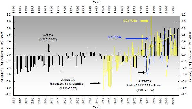
TEMPERATURE TRENDS 1880-2005
Annual global land temperature anomalies (AGLTA; source: NOAA Satellite and Information
Service-National Environmental Satellite, Data and Information Service) and annual local near-surface mean temperature
anomalies (ANSMTA, observed at stations XII-2615502 Cenicafé and I-2615515 Las Brisas). Anomalies are
defined as departures from the 20th-century average (1901-2000). Linear trends in near-surface ambient temperatures
observed in the area of the Claro River watershed exhibit rates of increase of about 0.22-0.25°C/decade.
|
Increases have been observed over recent years on the western flank of the Cordillera Occidental,
where total annual rainfall is strongly influenced by the orographic uplift of the westerly Chocó
low-level jet (Poveda and Mesa 2000, Vernekar et al. 2003). By contrast, historical time series
over the eastern flank of the Cordillera Central, where rainfall amounts are influenced by the
behavior of the easterlies and the low-level jet to the east of the Cordillera Oriental (Vernekar et
al. 2003), show general tendencies toward drier conditions. In the inter-Andean valleys some
stations exhibit increasing trends in rainfall while others have seen decreases. Along these
valleys rainfall amounts are affected by elevation and show influences of the northeasterly trade
winds, which in the area become valley currents that blow southward.
In the areas surrounding Los Nevados Natural Park, most of the climatic variables that
control the integrity of high-elevation ecosystems also show statistically significant changes (see
local scale in Ruiz et al. 2009 for specific rates of change). These variables include total annual
rainfall, maximum daily rainfall, minimum temperatures during the coldest days, maximum
temperatures during the warmest days, and minimum relative humidity. Analyses suggest that in
Los Nevados and at higher elevations on the western flank of the Cordillera Central, total annual
rainfall at elevations above the pluviometric optimum (ca. 1,500 m) is decreasing. Below this
elevation, some weather stations report slowly increasing trends. Daily precipitation records
suggest, in general, an increased occurrence of unusually heavy rainfall events. Minimum
temperatures on the coldest days show increasing trends at all elevations, suggesting that below-
freezing temperatures and cold days are becoming less frequent. Increases in minimum
temperatures at higher elevations are greater than those observed at lower elevations. Maximum
temperatures on the warmest days are also rising and, much like minimum temperatures, exhibit
faster increases at higher elevations. Finally, analyses suggest that minimum relative humidity
values have significantly decreased at higher elevations.
Changes in Cloud Characteristics, Sunshine, and Diurnal Temperature Range
One of the key factors of increased climatic stress in Colombian páramos is the change in cloud
cover (Ruiz et al. 2008). Cloud amounts are highly dependent on regional and local processes:
coupled interactions between sea surface temperatures (SSTs), wind patterns, and the latitudinal
displacement of the Inter-Tropical Convergence Zone drive regional cloudiness conditions on
intra-to inter-annual timescales. Satellite data show important reductions in cloud cover over the
high-elevation region over the last two decades of the 20th century. Observed changes in the
region seem to reflect these changes in cloud cover. Most of the weather stations on the western
flank of the Cordillera Central at elevations around the pluviometric optimum, exhibit
statistically significant decreasing trends in the total annual sunshine and the maximum,
minimum, and mean daily sunshine values. Such decreases in sunshine are consistent with
statistically significant increases in the total number of foggy days and decreases in the total
number of sunny days. By contrast, the total number of foggy days per month at higher
elevations has decreased slightly over the past decades. Finally, homogeneity analyses conducted
for Los Nevados Natural Park suggest that maximum, mean, and minimum diurnal temperature
range (minDTR) at higher elevations have increased over the past decades. Maximum DTR, in
particular, show statistically significant increasing trends at higher elevations, whereas lower
elevations show decreasing trends. The upward trend at higher elevations is a consequence of the
difference between the aforementioned rates of increase in minimum and maximum
temperatures.
Water Balance, High-Elevation Water Bodies, and Ice Caps
Changes have also occurred in hydrological regimes. Besides rainfall, water inputs to the
hydrological cycle in high-elevation watersheds include outflow from water bodies and aquatic
micro-habitats, mist, glaciers, and snowmelt. Our analysis of intra-annual cycles of the mean
streamflow of the Claro, Otún, and Chinchiná rivers suggest that water discharges follow the bimodal
annual cycles of rainfall observed in the surroundings of Los Nevados Natural Park, but
with a one-month time lag. Periods of high mean water discharge are usually observed during
April-May-June and October-November-December. Periods of low streamflow tend to occur
during January-February and July-August. Although minimum streamflows show similar intraannual
distributions, observed records exhibit important differences during the dry periods
January-February and July-August. During these months meltwater runoff from snow fields and
glaciers, as well as water inputs from high-altitude water bodies and turberas (bogs) increase
surface streamflow (i.e., streamflow is greater than would be expected from rainfall amounts
alone due to meltwater runoff). This effect is particularly pronounced in the Claro and Otún river
basins. By contrast, in the Chinchiná River, which does not receive meltwater runoff, and where
aquatic microhabitats are limited to a few areas at its headwaters, reductions in streamflow
during the critical dry months are considerable. during the critical dry months are considerable.
Decreases in annual rainfall observed at elevations above the pluviometric optimum and
increases in near-surface temperatures, particularly at higher elevations, are likely to decrease
streamflow. Exploratory analyses suggest decreasing trends in annual maximum and mean
streamflow values in the Otún and the Chinchiná rivers over the past 40 and 20 years,
respectively, although these trends are not statistically significant. Minimum discharges during
the critical months January-February and July-August show changes in the available historical
time series that are statistically significant. In the Otún River, minimum water discharges and
minimum streamflows during the driest period January-February exhibit decreases of ca. 1.0%
and >6.0% per decade, respectively, over the past 40 years.
Are these trends related to changes in the extent of high-elevation water bodies and icecaps?
Water bodies in the Los Nevados Natural Park have experienced reductions in surface area
over recent years, and some have already experienced natural sediment-filling and drying
processes, accompanied by a gradual colonization by local vegetation. However, water bodies
also exhibit a marked seasonality driven by regional climatic conditions. Increases in their water
levels are common during April-May and October-November, whereas decreases typically occur
during December-January-February and July-August-September. On inter-annual timescales,
high-elevation water bodies show dynamics related to the warm and cold events of the El Niño
Southern Oscillation. Specifically, significant drought-induced shrinkages with respect to past
reference shorelines are observed after above-normal summers that commonly accompany the El
Niño warm events.
On the other hand, the Molinos glacier on the western flank of El Ruiz Nevado and the
Conejeras glacier tongue on the western flank of the Santa Isabel Nevado have retreated
dramatically over recent years (Euscategui 2002, Ceballos et al. 2006, IDEAM 2008). These
retreats have been forced by volcanic activity, changes in climatic conditions, and changes in
local surface albedo. Although there is limited information to infer the potential impacts of the
changes in the extent of high-elevation water bodies and ice-caps on the ecosystem as a whole,
the disappearance of water bodies and turberas and the retreat of mountain glaciers are probably
undermining the integrity of páramo ecosystems. It is likely that the change in water availability
has and will continue to have a sizable effect.
High-Elevation Fires
Fire events are one of the most serious threats to the integrity of high-Andean ecosystems and
one of the most critical challenges for the conservation of protected areas. At higher elevations,
fires cause numerous and almost-irreversible damage to páramo soils, wetlands, fauna, and flora.
Fire-induced changes in the structure and composition of páramo ecosystems affect their
provision of several environmental goods and services. In the surroundings of Los Nevados,
lower-elevation areas and buffer zones are inhabited by smallholder farmers whose main
productive activities include grazing dairy cattle and the cultivation of potato crops. Fires are
usually set to regenerate grass for livestock, prepare land after harvesting crops, and expand
cultivated land areas. These burns are not controlled appropriately and often spread into nontarget
natural vegetation in páramo zones. Fires are particularly hazardous during the dry season
given the high to very high vulnerability of páramo habitats to the occurrence and rapid spread of
fires during this period. fires during this period.
Historical records of fires in Los Nevados extend back to 1994 (source: Unidad
Administrativa Especial del Sistema de Parques Nacionales Naturales). These records include the
worst ecological disaster that has occurred in protected Colombian high-elevation ecosystems,
namely the fire of unprecedented severity that took place in the surroundings of the Laguna del
Otún in July 2006 (Lotero et al. 2007). This event lasted for almost eight days and affected more
than 4% of the of the park. Sadly, since 1994 the annual number of fire events, the total area
affected per year, and the average fire duration show strong increasing trends. This is the result
of several factors such as a weak institutional capacity to react to fires, more combustible
material in the area, and climatic conditions more favorable to the spread of fires. Most events
have been induced by or are related to human activities, but it is likely that changing climatic
conditions have favored their rapid spread. Increases in the number of events and affected areas
seem to correlate with the increasing and decreasing trends observed in temperature and relative
humidity records (see above), respectively, gathered at nearby weather stations.
This link does not appear to be a coincidence. Testimonies of local experts and park
guards support the links between the current rapid spread of fire events and the observed changes
in climatic conditions in the area. Also, an association between the timing of fire events, the total
area affected per month, and the intra-annual cycles of climatic conditions in the area of Los
Nevados has been observed. Most fire events occur during the dry seasons June-July-August
(JJA) and December-January-February (DJF). Higher values of maximum temperatures linked to
lower relative humidity and rainfall set the stage for a potential increase in the spread of small-
scale fire events during these trimesters. The maximum number of events and greatest area
affected per month are observed during the trimester JJA. However, when excluding the
unprecedented fire event of July 2006, the highest value of total area affected per month occurs
during DJF. In summary, although changing conditions are not directly causing an increase in
high-elevation fires, drier conditions may favor their rapid spread. Thus, larger affected areas and
greater duration of fires are early warnings of the páramo ecosystems' increasing vulnerability.
Model Projections
Model projections consistently suggest future climatic conditions will be unfavorable for páramo
life zones (Vuille et al. 2003, Diaz et al. 2003). Hulme and Sheard (1999) used the outputs of six
Global Climate Models (GCMs) to propose future climate scenarios for the Northern Andes.
According to their results, the total annual rainfall in the central region of the Cordillera Central
is expected to be above the 1961-1990 normal annual value for all emission scenarios. They also
suggest that increases in mean annual temperatures are expected throughout the region. Giorgi
and Bi (2005) used atmosphere-ocean coupled GCM simulations for northern South America to
predict increases in rainfall during future wet seasons and decreases during dry seasons. Also,
near-surface temperatures are predicted to be above historical normal conditions. Bradley et al.
(2006) used GCM results to suggest that, at 5°N and at elevations of 3,000-5,000 m, mean
annual temperatures are expected to increase over this century under emission scenario A2 of
Meehl et al. (2007). For Colombia recent statistical downscaling techniques of GCM outputs
were used to estimate future climatic conditions under a 2xCO2 emission scenario (Departamento
de GeografíaUniversidad Nacional de Colombia 2005). On a national scale and for the Alto
Cauca hydroclimatic region, total annual rainfall is expected to change up or down depending on
the model, but mean annual ambient temperatures are consistently expected to be above the past
mean.
GCM outputs indicate an increase in the elevation of clouds under a future warmer world
(Meehl et al. 2007). They also suggest that most tropical areas will experience a decrease in net
cloud cover over all layers. Based on our analyses of January SST anomalies (Ruiz et al. 2009),
we suggest that a significant decrease in cloud cover in the high-elevation region is likely to
occur over the next 50 years under normal conditions. Our predicted decrease of 6.8% in total
cloud cover, relative to the period 1984-2001, is 1.4 times greater than (but consistent with) the 2.0%
annual mean change suggested by Meehl et al. (2007) for the period 2080 to 2099, relative
to 1980 to 1999. We also argue that if a strong El Niño event were to occur by 2050, the
reduction in January monthly average cloud cover could be more critical.
Changes in the structure, composition, integrity, and extension of high-elevation
ecosystems inhabiting the Claro River watershed and nearby areas are likely to occur over the
first half of this century. Ongoing changes in climatic conditions could force upward shifts in the
transitions between life zones, which would lead to the appearance of new environments, the
expansion of some others, and reductions in the extent of the subalpine (páramo), alpine
(superpáramo), and nival (glacial) elevational belts. The future distribution of these ecosystems
will depend on their capacity to adapt to the expected climatic changes. Our analyses suggest that
by 2050 climatic conditions in the watershed and the region will likely be suitable for the
colonization of lower montane dry forest (LMdf) and montane moist forest (Mmf). A 56%
increase in the montane wet forest (Mwf) surface area could also occur. On the other hand,
subalpine rain páramo (SArp), alpine rain tundra (Art) and nival (N) life zones could experience
reductions of about 31%, 53%, and 80%, respectively, by 2050. In terms of the Cuatrecasas
classification, reductions in the areas of subpáramo, páramo, superpáramo, and nival zones could
be 83%, 22%, 53%, and 80%, respectively. With respect to the entire páramo zone, such
reductions correspond to a total decrease in area of about 54%.
Potential Impacts on Ecosystem Integrity
Although their impacts on the integrity of high-elevation habitats are very difficult to assess,
changing climatic conditions could lead to the disruption of páramo and cloud forest ecosystems.
Some of the expected impacts include:
- Upward migration of low-elevation plant species are expected to occur, reducing the extent
of páramo habitats. As the climate warms and ice caps melt a shift in life zones to higher
elevations could be expected as, over long time intervals, these zones would maintain their
relationships to the snow line. However, the inferred rapid upward changes in the Lifting
Condensation Level and field-observed retreats of snowline (both considered good
approximations of upward shifts in the transitions between life zones) suggest that several
high-elevation plant species will most likely be unable to migrate upward. Changes in
temperature could favor the upslope migration of many montane species, but might also
have a devastating impact on those species that have adapted to and become dependent on
extreme conditions at high altitudes.
- Elevational changes in sunshine and rainfall could contribute to an increase in the rate of
desertification of montane habitats, which today house an important fraction of global
biodiversity.
- Areas where only snow or drizzle used to fall could be experiencing heavy rain due to the
rapid upward shift of the freezing level. Glacier margins may be at increasing risk of
retreat, contributing to a continued diminution of the self-regulation capacity of the
hydrological system.
- Decreases in the amount of cloud and fog cover, driven by changes in atmospheric
stability, will have significant impacts on the net radiation balance. As a consequence,
glacier mass, high-elevation water bodies and mountain species could be further affected.
- Finally, higher solar energy is expected to accelerate the hydrological cycle and increase
evapotranspiration, having strong effects on water bodies and aquatic microhabitats.
Combined, these impacts constitute a serious threat to unique páramo habitats and, consequently,
to the water supply in the region. In the foreseeable future it will be more expensive to supply
water for human consumption, power generation, and agriculture (Vergara et al. 2007, Vergara
2009). Ambitious sustainable management strategies are now urgently required to protect these
unique, rich, fragile, and highly endangered environments.
Literature Cited
Bradley, R. S., M. Vuille, H. F. Diaz, and W. Vergara. 2006. Threats to water supplies in the
tropical Andes. Science 312:1755-1756.
Buytaert, W., R. Célleri, B. De Bièvre, F. Cisneros, G. Wyseure, J. Deckers, and R. Hofstede.
2006. Human impact on the hydrology of the Andean páramos. Earth-Science Reviews
79:53-72.
Castaño, C. (ed.). 2002. Páramos y ecosistemas alto andinos de Colombia en condición hotspot
& global climatic tensor. Bogotá: Ministerio del Medio Ambiente and Instituto de
Hidrología, Meteorología y Estudios Ambientales. 387 pp.
Ceballos, J. L., C. Euscategui, J. Ramirez, M. Canon, C. Huggel, W. Haeberli, and H. Machguth.
2006. Fast shrinkage of tropical glaciers in Colombia. Annals of Glaciology 43:194-201.
Cuatrecasas, J. 1934. Observaciones geobotánicas en Colombia. Trabajos del Museo Nacional
de Ciencias Naturales, Serie Botanica 27:1-144.
Departamento de GeografíaUniversidad Nacional de Colombia. 2005. Escenarios de cambio
climático para el territorio colombiano. Fase PDF-B, Integrated National Adaptation
Pilot (INAP) -Informe Ejecutivo. Bogotá: Universidad Nacional de Colombia. 19 pp.
Diaz, H. F., M. Grosjean, and L. Graumlich. 2003. Climate variability and change in high
elevation regions: past, present and future. Climatic Change 59:1-4.
Euscategui, C. 2002. Estado de los glaciares en Colombia y análisis de la dinámica glaciar en el
Parque Los Nevados, asociada al cambio climático global. MSc thesis. Bogotá:
Universidad Nacional de Colombia, Facultad de Ciencias, Departamento de Geociencias.
LINK
Foster, P. 2001. The potential negative impacts of global climate change on tropical montane
cloud forests. Earth-Science Reviews 55:73-106.
Giorgi, F., and X. Bi. 2005. Updated regional precipitation and temperature changes for the 21st
century from ensembles of recent AOGCM simulations. Geophysical Research Letters 32:L21715.
Gutiérrez, M. E., P. A. Zapata, and D. Ruiz, 2006. Entendimiento de las señales de cambio
climático y variabilidad climática en la oferta hídrica superficial de cuencas
hidrográficas en zonas de alta montaña. Envigado, Antioquia: Environmental
Engineering Program, Antioquia School of Engineering. 160 pp.
Hulme, M., and N. Sheard. 1999. Escenarios de cambio climático para países de los Andes del
Norte. Norwich: Climatic Research Unit, University of East Anglia. 6 pp.
LINK
Holdridge, L. R., 1987. Ecología basada en zonas de vida. San José, Costa Rica: Instituto
Interamericano de Cooperación para la Agricultura.
Instituto de Hidrología, Meteorología y Estudios Ambientales. 2008. Los glaciares colombianos:
expresión del cambio climático global. LINK
Lotero, J. H., L. N. Trujillo, W. G. Vargas, and O. Castellanos. 2007. Restauración ecológica en
páramos del Parque Nacional Natural Los Nevados: experiencias de restauración
ecológica en páramos luego de incendios forestales en la cuenca alta del río Otún. Bogotá: Editorial Andina. 152 pp.
Meehl, G. A., T. F. Stocker, W. D. Collins, P. Friedlingstein, A. T. Gaye, J. M. Gregory, A.
Kitoh, R. Knutti, J. M. Murphy, A. Noda, S. C. B. Raper, I. G. Watterson, A. J. Weaver,
and Z.-C. Zhao. 2007. Global climate projections. In Climate change 2007: the physical
science basis. Contribution of Working Group I to the Fourth Assessment Report of the
Intergovernmental Panel on Climate Change, edited by S. Solomon, D. Qin, M.
Manning, Z. Chen, M. Marquis, K. B. Averyt, M. Tignor, and H. L. Miller. Cambridge: Cambridge University Press.
Pabón, J. D. 2003. El cambio climático global y su manifestación en Colombia. Cuadernos de Geografía 12(1-2):111-119.
Pabón, J. D. 2004. El cambio climático y sus manifestaciones en Colombia. Innovación y Ciencia 11(3-4):68-73.
Poveda, G., and O. J. Mesa. 2000. On the existence of Lloró (the rainiest locality on Earth):
enhanced oceanlandatmosphere interaction by a low level jet. Geophysical Research Letters 27:1675-1678.
Ruiz, D., H. A. Moreno, M. E. Gutiérrez, and P. A. Zapata. 2008. Changing climate and
endangered high mountain ecosystems in Colombia. Science of the Total Environment 398:122-132.
Ruiz, D., M. P. Arroyave, A. M. Molina, J. F. Barros, M. E. Gutiérrez, and P. A. Zapata. 2009.
Signals of climate variability/change in surface water supply of high-mountain
watersheds case study: Claro River high mountain basin, Los Nevados Natural Park,
Andean Central Mountain Range, Colombia. Medellin: World Bank Group and School of
Engineering. 207 pp.
Vergara, W. (ed.). 2009. Assessing the potential consequences of climate destabilization in Latin
America and Caribbean Region, Sustainable Development Working Paper 32.
The World Bank. 115 pp. LINK.
Vergara, W., A. M. Deeb, A. M. Valencia, R. S. Bradley, B. Francou, A. Zarzar, A. Grünwaldt,
and S. M. Haeussling. 2007. Economic impacts of rapid glacier retreat in the Andes.
EOS, Transactions American Geophysical Union 88(25):261-264.
Vernekar, A. D., B. P. Kirtman, and M. J. Fennessy. 2003. Low-level jets and their effects on the
South American summer climate as simulated by the NCEP Eta model. Journal of Climate 16:297-311.
Vuille, M., R. S. Bradley, M. Werner, and F. Keimig. 2003. 20th century climate change in the
tropical Andes: observations and model results. Climatic Change 59:75-99.
ABOUT THE AUTHORS
Daniel Ruiz Carrascal is a Principal Investigator on hydroclimatology, 'Gestión del Ambiente para el Bienestar Social' (GABiS), at the School of Engineering in Antioquia, Colombia. He is currently a Graduate Research Assistant and PhD candidate at the International Research Institute for Climate and Society, Columbia University. For more on the work of this author, click here.
María del Pilar Arroyave Maya is Director, 'Gestión del Ambiente para el Bienestar Social' (GABiS), at the School of Engineering in Antioquia, Colombia. For more on the work of this author, click here.
María Elena Gutiérrez Lagoueyte and Paula Andrea Zapata Jaramillo are research assistants, 'Gestión del Ambiente para el Bienestar Social' (GABiS), at the School of Engineering in Antioquia, Colombia.
|


![[groups_small]](groups_small.gif)