The transition to a steady state economy—in which humans, their operations, and their artifacts are nested harmoniously within the economy of nature—is fundamentally about reconciling human needs with the needs of nature. Leaving space for habitat and the functioning of natural systems is critical to our survival and the survival of myriad other organisms.
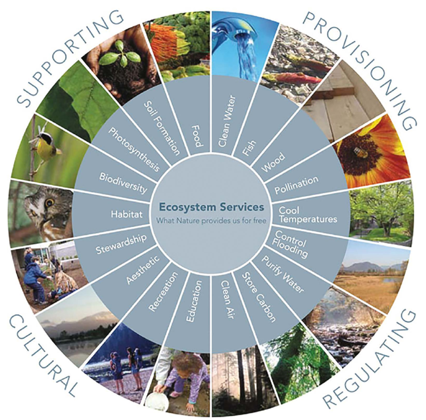
Natural and traditional agricultural ecosystems are autotrophic (‘self-feeding’), meaning they are capable of regenerating resources and assimilating wastes. Cities, by their nature, are heterotrophic (‘other feeding’); that is, they draw resources, energy, and materials from their surroundings, and often import materials from afar. Unurbanized areas provide “green infrastructure”—natural capital like a river or bees—that yields life-supporting ecosystem services such as water provision or pollination. Cities need to leave sufficient green infrastructure across the regional landscape.
Yet instead of preserving green infrastructure, our gray infrastructure—dwellings, factories, and stores, and the roads that tie these elements together—displaces natural systems. Sprawling forms of development, which are often monotonous and low-density, and which utilize land inefficiently, are the most injurious. Sprawl fragments and degrades biocapacity.
It’s clear that densification would be better for humans and natural systems. But a critical tension exists between densifying gray infrastructure and preserving green infrastructure. Density can create oppressive urban landscapes that are unattractive, difficult to inhabit, and detrimental to social interactions—and therefore incompatible with human flourishing. Paradoxically, such density can stimulate sprawl, as people seek to find connections to nature that are absent in concrete surroundings.
In other words, ‘total infill’ reduces livability, which backfires into sprawl, the prevention of which is a chief goal of compact urban form. Furthermore, urban areas devoid of green infrastructure offer little habitat for other organisms, and no ecological services. Such urban habitat deserts place a greater burden on surrounding natural areas to “offset” services, making up for services lost in urban areas.
Resolving the Tension between Density and Green Infrastructure
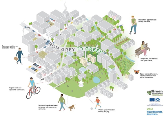
To avoid backfiring into sprawl, densification of human habitation needs to intercalate sufficient greenspaces within urban areas for human aesthetic and recreational needs, and to establish biodiversity within urban settings. Planning new developments or retrofitting urbanized areas to integrate green infrastructure encourages dense living. This reduces pressure to sprawl while diminishing the heterotrophic impact of human habitation.
What might sustainable densification look like? And what opportunities exist to deploy green infrastructure? A helpful guide for communities is the Green Infrastructure Scotland Design and Placemaking initiative, which identifies opportunities for sustainable urban design.
Certainly the lowest hanging fruit in planning for sustainable densification is conversion of existing greenspaces that are ineffectively utilized. Residential and commercial lawns are common examples, as are lawn spaces in parks and easements that could instead harbor diverse native habitats. Institutional lawns, such as those at schools, could provide opportunities for the public or students to design and implement natural habitat.
Other types of green infrastructure include rain gardens, catchment ponds, green walls and roofs, planters and pocket parks, bio-hedges, and berry and fruit trees lining sidewalks and bikepaths. Planning for wildlife would include connecting greenspaces to create migration routes. These areas would include spaces for public gatherings, such as public squares for mingling, conversation, and recreation.
Greening urban areas would also include space for food production, a potentially important ecological service of green infrastructure. Some lawns could be converted to small orchards or gardens for individuals or groups to grow vegetables for themselves or the community. Estimates of potential food production in urban settings vary, but even conservative estimates indicate that a month’s supply of residents’ demand for fruits and vegetables per year is possible.
Spatial Arrangement of the Urban-Rural Continuum
Another key aspect of planning for densification involves increasing density from low (in rural areas) to high (in the urban core) to help mitigate human impact on the landscape.
Our tendency to ignore the importance of ecological services and instead to import resources from elsewhere has led to the haphazard pattern of sprawl that plagues most cities and counties in the USA and Canada. The age of sprawl was facilitated by cheap energy, and by a general desire to escape the city and gain access to greenspaces. Separation of land uses—dividing the landscape into commercial, industrial, and residential zones—was made possible by private car travel, which then became indispensable to suburban life. This mode of inhabiting the landscape is antithetical to observing biocapacity and limits. It has also exacerbated social ills such as social isolation and segregation.
Practitioners of urban design known as New Urbanists have effectively diagnosed this problem and prescribed revisiting the advantages of traditional urban design. A basic representation of the New Urbanist approach to landscape-level planning is transect analysis, which conceptualizes an optimal urban-rural continuum.
Transect analysis provides a planning lens that ensures space for natural habitat and farms in the natural and rural zones. Use of space gradually evolves to a suburban zone with significant greenspace, then to an urban general zone with greater density, and finally to the urban center and urban core zones. Urban general, center, and core zones don’t preclude greenspaces for gardening and integrating natural plantings and ideally would invite them.
But, as noted, not all density yields a high quality of life. New Urbanists are mindful of this and recommend a density of 50 to more than 100 units per acre at the urban center and core, with buildings no more than four to five stories in height. Furthermore, New Urbanists provide a number of approaches to ensure aesthetic quality and to expand public space.
Beyond promoting a human scale of development by choosing modest-sized buildings, planners can avoid monotonous streetscapes by paying attention to the architecture and the articulation of the structure along a streetscape. Areas set back offer small but important greenspaces for people to gather and interact. Pedestrian-friendly streets are fundamental to good urban density.
Furthermore, although the trend in sustainable urban design is to increase density toward the city core, a polycentric form can also be a successful model. In this case, town centers or neighborhood activity centers are established in various neighborhoods, each offering goods and services, typically within walking distance.
The heterogeneity of the built environment permits planners to integrate green infrastructure within and between the centers, giving residents contact with nature. It also allows for siting of green infrastructure such as rain gardens to treat stormwater runoff and to mitigate the heat-island effects of radiant heat from streets and buildings.
Residential areas can also be designed to complement nature. Zoning code changes that permit food production and yard naturalization programs make space for other organisms while creating compact neighborhoods that optimize economic, social, and cultural interactions.
Within this context, densification of human habitation becomes essential to a healthy and well-functioning community, and the transect model is an important tool for lowering the community’s ecological footprint. Knowing we must reconcile the biophysical limits of our finite world with our place within it, we can applaud the New Urbanist efforts to mitigate the human impact. The transect model does much to reconcile the tension between the built environment and protecting and limiting the impact on the ecological services provided by green infrastructure. But from a steady-state perspective, it does not fully resolve the question of evaluating limits. In fact, densification is often couched in terms of “green growth.” (Such is the power and persuasion of the growth imperative.)
Deepening the Analysis: Biocapacity and Ecological Footprint
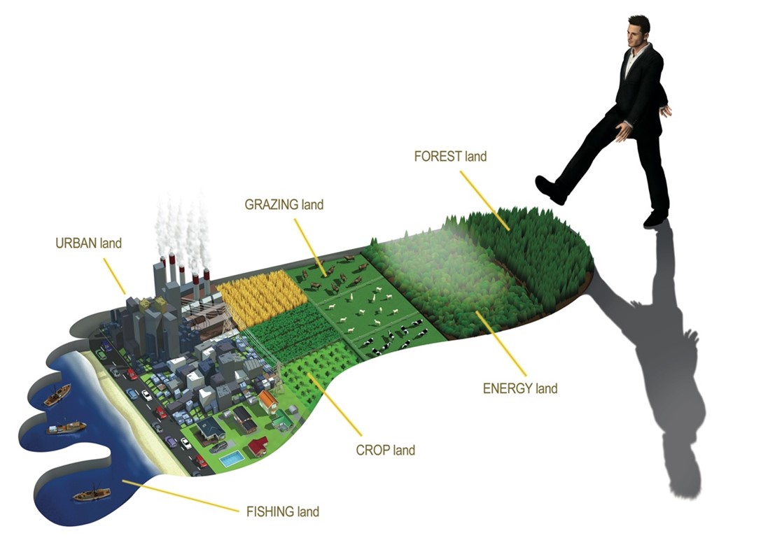
A deeper analysis of density is needed to fully account for the impact of a city’s development on the greater system. Here we can make use of ecological footprint (EF) analysis, which compares an area’s biological capacity to humanity’s use of that capacity. Biocapacity refers to the ecological productivity of an area, including the area’s ecological services, materials, and energy. Our use of those goods and services is known as our ecological footprint.
Comparing ecological footprint to biocapacity allows analysts to determine if a community is living within its ecological budget. The Global Footprint Network has been assessing global and regional ecological footprints for decades. At the global level, humanity is running an ecological deficit, drawing down our planet’s natural capital and reducing the regenerative capacities on which we depend. Humanity’ s 2022 global ecological footprint exceeded 73% of global biocapacity. It continues to grow as human population and GDP expand.
A good step toward living within the boundaries of a community’s ecological capacity is to reduce its imports of biological resources (which are counted in a community’s footprint). This requires quantitative analysis by planners of imported food, fuel, and other materials when determining land-use policies. Although mostly deployed at the scale of large cities and countries, footprint analysis is an ideal tool to evaluate a community’s impact. Because land use is governed predominantly by local planning and zoning authorities, local government policies are key to limiting and reducing our impact. Impact analyses and action plans can be used to safeguard local green infrastructure and reduce a community’s footprint.
The advantages of EF analysis are significant. Instead of viewing the landscape as wide open for human development, citizens would begin to regard it as integral to their life support. EF analysis provides a powerful tool for resolving the conflict between development and conservation.
Additionally, EF situates a community’s impact within a global context and allows for comparison with the footprints of other countries. Understanding and comprehending the implications of our impact is an integral component of ecological literacy that can cultivate community policies and individual behaviors to reduce impacts.
Naturally, EF analysis could be an important instrument for limiting sprawl. Ecologically sensitive areas that protect the biocapacity of the county would be prioritized. This process of accounting is enabled by mapping natural features using a GIS-based environmental resource inventory. Such maps can work in tandem with footprint analysis to identify lands for special consideration, including those with fragile soils, steep slopes (to protect against erosion), and wetlands, as well as prairies, woodlands, riparian areas, and larger contiguous tracts to protect species richness and diversity and provide clean water, food-producing capacity, and other ecosystem services.
Such analyses have been conducted for cities and countries, and individual ecological footprints can be determined as well. Ideally city and county planners should include these tools to evaluate and protect areas to maximize ecological services.
Intercalating greenspace and implementing a transect method of development, combined with EF analysis, can help communities move to the compact development essential for preserving space for other living beings that share our planet.


![[groups_small]](groups_small.gif)